

Future Jobs Projects
Future Jobs has supported our academic partners in developing cutting edge laboratories and curriculums to help prepare students for the job market since 2007. Our projects are employer-driven in nature and reflect the skills and training our employers need to fill their jobs openings. | 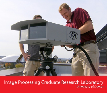 |
This project is a senior capstone course that was established and taught in 2008 in the Computational Science Department at Wittenberg University. This course was designed to prepare educational modules in data analysis and visualization by incorporating direct employer input from Qbase (www.4qbase.us). Wittenberg has also expanded its existing healthcare course work to focus on the data analysis and visualization of information.
The course provides an introduction as well as valuable experience in addressing challenges for the integration of information from multiple sources such as text, web, images, and databases. The course includes a review of common industry standard formats in use today and looks at trends across several industry sectors. The curriculum provides students with a glimpse into the management and integration of volumes of assorted data and data sources that would exist in a company such as Qbase.
The project is a brand new curriculum and laboratory for students to specialize in the field of Geo-Spatial Technologies at Clark State Community College. The program established in 2008, began offering a certificate degree in Geo-Spatial Imaging. The program expanded to offer an applied Associates Degree in 2010 with approval from the Ohio Board of Regents. The curriculum was designed and implemented in close collaboration with CACI and Woolpert to help train future professionals in this continuously growing field.
"This program is about building a new technology workforce and makes it possible for us to offer the opportunity for a select group of students to move forward quickly into good jobs", Karen Rafinski, President at Clark State.
This program is a four-week summer bridge program focused on STEM disciplines at Central State University that started in 2008. The Future Jobs STEM Summer Bridge Program is designed for incoming freshman majoring in the STEM disciplines to give them the basic tools needed to succeed throughout their matriculation at Central State. 27 students have participated in the Future Jobs Summer Bridge Program during the summers of 2008 and 2009 and all participants are still enrolled at CSU.
During the four weeks, students have the opportunity to learn about the importance of STEM and career paths they can take to find jobs right here in Ohio. The program wraps up with a capstone research project where each student presents information on a specific STEM-related topic. "Future Jobs funding and support of the university's science based Summer Bridge Program exemplifies a strong partnership committed to building sustainable jobs and a quality next generation workforce for Ohio," John Garland, President at Central State.
This program was started in May of 2009 in the Graduate School at the University of Dayton. It was developed by UD's staff of talented professors and researchers and close collaboration with Geo-spatial companies in the Dayton, area. It is designed to tackle and explore solutions for the analysis of image sensor data that can be acquired from an array of cameras. This research will be used for government and private sector businesses that want to enhance Geo-Spatial technologies for use by the US military.
This program focuses on algorithms and also tries to create a working model that can incorporate periodic updating of the present models, auto-focus capabilities of multiple camera arrays, and proper image registration. This initiative has improved camera models that are necessary for the seamless integration of multiple camera data with the aid of several graduate students and faculty.